Young Volcanic Landscapes series
Australia is often referred to as an ancient, stable continent. There are no active volcanoes on the mainland and there relatively few earthquakes- compare to other neighboring countries on the so-called "Pacific Ring-of-Fire". So many Australians are surprised to find out that there several volcanic provinces on the eastern and south-eastern part of Australia that have erupted within the last 10,000 years. These volcanoes are young enough to have been witnessed by Aboriginal people and form part of their Dreamtime stories in certain regions. Geologists consider these relatively recent Australian volcanoes as "dormant" not "extinct".
In eastern Australia, there are two major regions of young volcanoes. The first is situated in Far-North Queensland (FNQ); covering the Atherton Tableland, McBribe and Nulla Basalt Provinces. The second major region is found at the southern end of the continent in central-western parts of Victoria and south-eastern South Australia (called the Newer Volcanic Province). These young volcanic landscapes will be the focus for a new series of paintings that will depict some of the unique and/or characteristic features of these landscapes.
Undara Lava Tubes
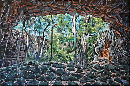
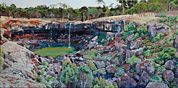
The first series of paintings will be based on the unique landscapes of the Undara Lava Tubes. Situated in Undara Volcanic National Park, visitors can accessed this Park via the Undara Experience Resort. This National Park covers the Undara volcano which last erupted 190,000 years ago. Part of this eruption resulted in 3 main lava tubes with the middle of these three tubes being part of a flow that extends over 160 km west of the Undara crater. Check this out on Google Earth- it is an amazing sight.
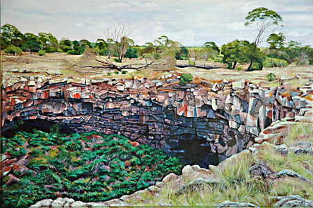
One of the main attractions at Undara is The Archway Lava Tube. This section of the middle Undara lava tube has 2 collapsed roof sections that has produced the "archway" in between. It is a spectacular site and has become the most visited of all the lava tubes at Undara.
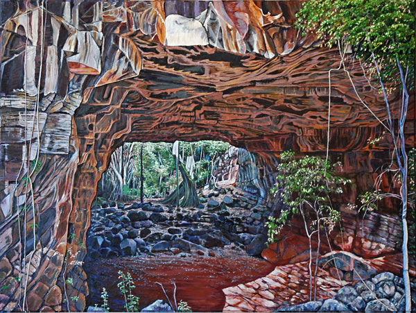
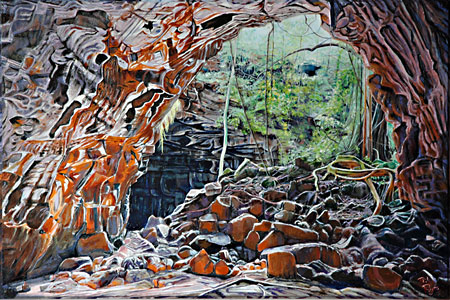
Thanks to Bob Gay, Tumbarumba, for providing the image for The Archway Lava Tube 3.
Other lava tubes open to the public are Barkers and Collins Road
.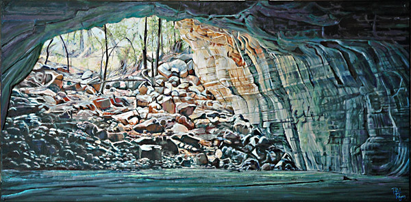
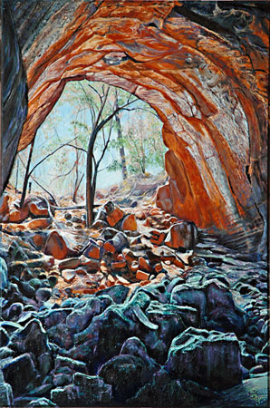
Those familiar with these Undara lava tubes will realise that I have removed all the stairs and walkways at these locations from the paintings. This is not a critique of the infrastructure- I just want to present these amazing landscapes with out any human paraphernalia.
If you wish to obtain more detailed information on the Undara Lava Tubes, there is recent conference paper by Anne Atkinson that gives a good overview.
Atherton Tableland
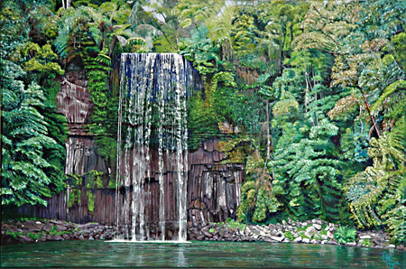
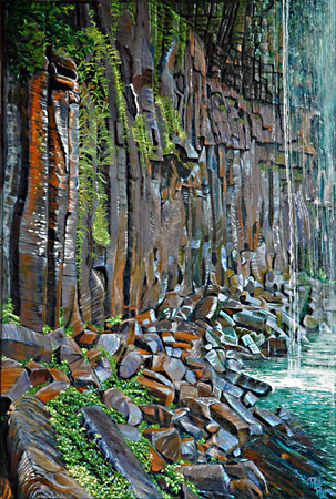
The Atherton Tableland is north-east of Undara and west of Cairns, FNQ. This idyllic tropical region has a recent volcanic past. Lava first erupted over 4 million years ago and there has subsequent eruptions up to 8000 years ago. Initial eruptions produced massive lava flows from shield volcanoes which flowed over large areas, filling old river valleys, flowing over the escarpment, and down nearly to the coast at Innisfail. High rainfall and a tropical climate has facilitated erosion of this basalt landscape to produce deep fertile soils and luxuriant rainforest. So it is now difficult to readily see any specific geomorphic features of the shield volcano lava flows other than the fertile rolling pastures of the Atherton Tableland. The exception to this are certain waterfalls that produce spectacular cross-sections of the basalt lava flows. Millaa Millaa Falls is one such place where several basalt flows are exposed, showing the vertical, columnar jointing.
Columnar jointing in basalt flows has always fascinated me. Elegant hexagonal (or polygonal) columns that have formed from slow cooling of amorphous molten lava. This is a feature of the two Millaa Millaa Falls paintings.
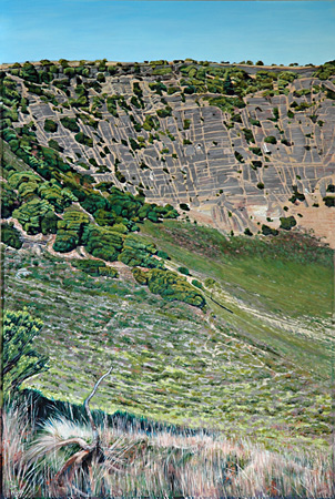
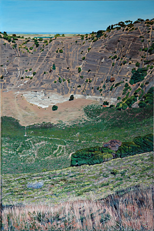
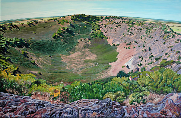
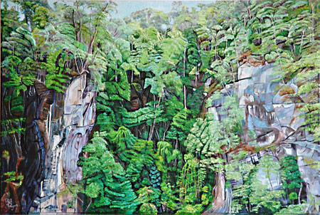
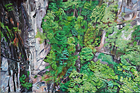
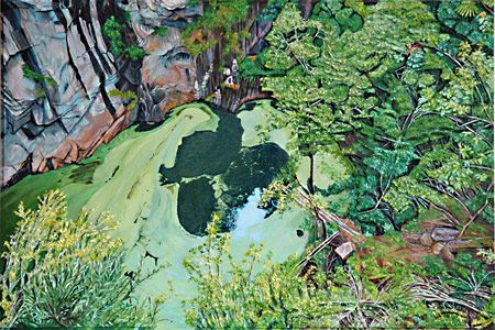
The more recent eruptions on the Atherton Tableland have produced scoria cones and maar lakes. When hot magma encounters a watertable below the land surface then explosive eruptions occur of mostly stream (with varying amounts of lava) that produce shallow craters that can subsequently fill with water. These are maar lakes such as Lake Barrine and Lake Eacham. A much rarer type of eruption is one that is caused by explosive stream with little or no magma. These eruptions blast a funnel of bedrock up into the air. If this material (plus any volcanic rock) refill the crater it is called a diatreme. If the the crater fills with water it can also be called a maar lake. Hypipamee Crater is one of these rare Phreatic eruptions on the Atherton Tableland and one of the most spectacular in the world. At Hypipamee, the eruption has blast a narrow funnel through an older granitic bedrock that is part of a mountain range on the western edge of the tableland. Viewing Hypipamee Crater from its rim is a disconcerting sight. It hard to comprehend the scene before you even if you have a knowledge of geology; the violence of the force that has produced the crater, it's size and shape are difficult to digest in part because your viewpoint and its perspective. This is why I have produced a vertical triptych of paintings of Hypipamee Crater to try to capture some of the strangeness of this volcanic landscape.
The Nulla Volcanic Province, west of Townsville has extensive lava flows. The youngest flow is the Toomba dated at 13000 years old. At Dalrymple National Park, the Toomba Flow follows the path of an older flow (Birdbush) which filled part of the old Burdekin River channel directing the river to the north and east. Lolworth Creek now follows the southern and western edge of the Toomba Flow and at Lowes Basin separates the basalt from the Devonian Burdekin Limestone. It is this stark contrast between the pale dipping strata of the limestone and the dark basalt flow that is depicted in the paintings Lowes Basin 1 and 2. Young versus old, white versus black, mediate by flowing water. Lowes Basin itself has formed from an oxbow of Lolworth Creek cutting into the Toomba basalt (Lowes Basin 1).
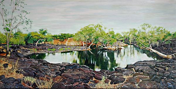
Thanks to Michael Bradley for providing the images of Lowes Basin used for the above paintings.
Central Victoria
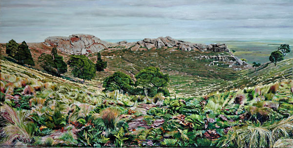
The Newer Volcanic Province is a volcanic field stretching 410 km from Melbourne to the Mt. Burr range in South Australia, covering 19,000 km2 and containing 704 eruption points from 416 volcanic centres. Background information about the Newer Volcanic Province can found at Kanawinka Geotrail and the Penshurst Volcanic Discovery Centre. Penshurst is at the base of Mt Rouse, one of the many volcanoes rising above the extensive lava plain. Mt Rouse is a composite cone of basalt and scoria.
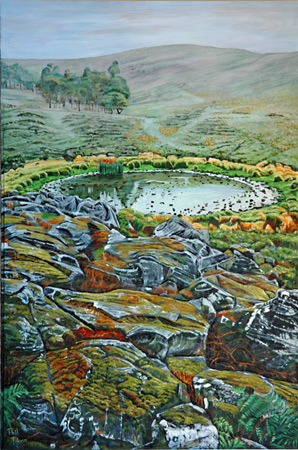
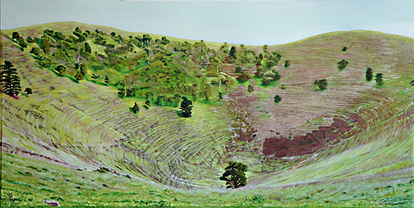
The crater lake on Mt Rouse is the subject of 2 paintings; Mt Rouse Crater Lake Duo. One of the features of most volcanic crater lakes is their location within a cone with only internal drainage. That means that you can view the crater lake from within the cone, then walk around the crater at the same elevation and see basically the same landform. Crater lakes are usually radially symmetrical, unlike most other lakes, natural or man-made.
Looking west from Mt Rouse, you can see the neighbouring volcano Mt Napier. Mt Napier is a large volcano comprising a breached scoria cone which last erupted 32,000 years ago.
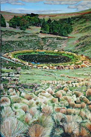
Mt Noorat is another impressive scoria volcano 1km north of Noorat. While this volcano had multiple eruption points, the main crater is an impressive inverted cone. Sheep grazing over the area have produced a series of near concentric tracks within this crater which emphasises the geometry of the landform giving the impression of a petrified whirlpool.
Thanks to Evelyn and Kris Jacobsen for supplying the images for this painting.
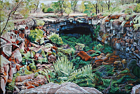
One of the lava flows from Mt Napier produced lava tubes similar to those found at Undara. Byaduk Lava Caves are situated SW of Mt Napier. Byaduk Lava Caves 1 and 2 show 2 scenes where the lava tube roofs have collapsed, exposing the caves.
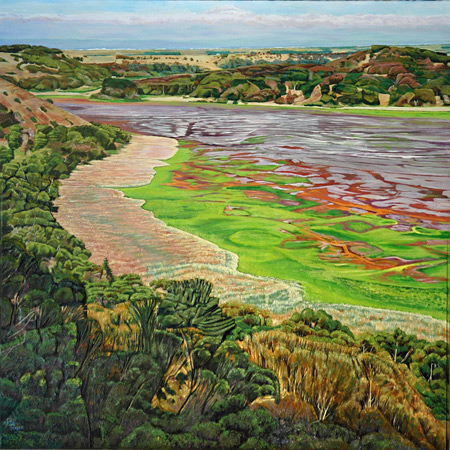
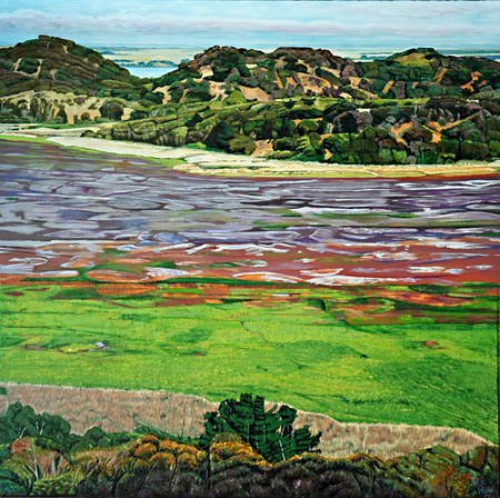
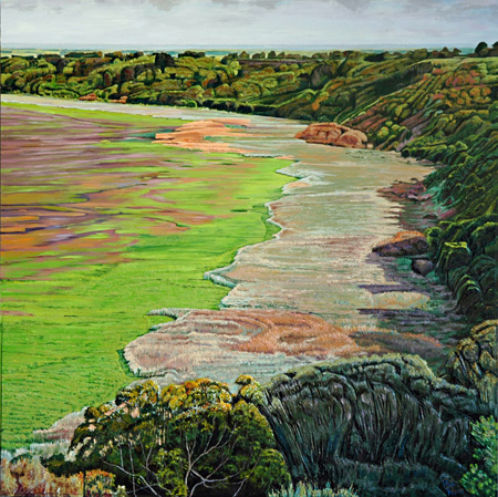
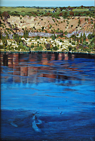
Maar lakes are common within the Newer Volcanic Province. Tower Hill Volcano, near Warrnambool Victoria is one of the most spectacular of these maar lakes. It is a complex volcanic centre comprising a main crater 3.2 km x 2.4 km with a surrounding tuff ring but within that crater there are a series of scoria cones. The eruption is dated at 20,000 years BP. Tower Hill has been the subject of a number of significant art works. In 1855, Eugene von Guérard painted Tower Hill and more recently in 2016 Hobie Porter produced his Unnatural History: The Tower Hill Project.
Tower Hill Maar Trilogy depicts the early morning view of Tower Hill from the eastern rim of the crater. In April 2016, Tower Hill lake was nearly dry and the retreating water had produced intriguing and colourful patterns of vegetation and drying sediment with evaporated salt crusts. The triptych composition was adopted to convey the scale of this volcanic landscape.
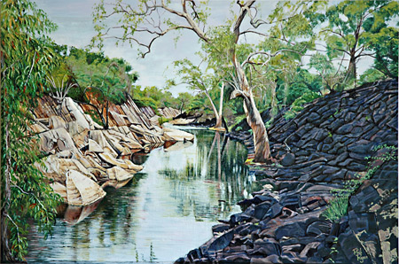
Wannon Falls can found 19km west of Hamilton on the Mt Gambier road. This site is on the western edge of the Newer Volcanic Province and been created by a basalt flow that actually flowed up the old river valley from an eruption point to the south-east some 2 million years ago. This basalt flow has protected the old river bed from erosion but it is slowly been collapsing under the power of the modern Wannon River, exposing the basalt cap and underlying softer strata. The undercutting of the lava flow at the Falls has produced landforms similar to the lava caves at Byaduk.
Wannon Falls has been the subject of a number of paintings dating from the colonial times onwards. An example is Louis Buvelot's painting of Wannon Falls dated 1872.
Mt Gambier is a major town in south-eastern South Australia. It is named after a prominent local volcano that projects above an otherwise flat limestone plain. This volcano is just one of at least 14 eruption points along a NW-SE fault line in the region. The Mt Gambier Volcanic Province is considered part of the main Newer Volcanic Province in Victoria and contains the most recent volcanism on the Australian mainland.
Blue Lake is on the SE end of this volcanic complex and is maar lake that was produced after 2 smaller volcanoes met an explosive end. The resulting large crater has filled from ground water and is renown for its occasional startling blue colour (various theories to the cause of this). Blue Lake Crater depicts the Lake and crater wall from the eastern edge in early morning light. Exposed on the face of the crater wall above the waterline is a summary of Blue Lake's geological history; lowest is the flat limestone strata (white outcrops) through which the volcano erupted, above the limestone are basalt lava flows from the early volcanoes (gray outcrops), and finally a thick layer of volcanic ash and limestone aggregate that was deposited after the last catastrophic explosion (about 5000 years age). The resulting painting is a simple composition of varied coloured horizontal bands that contain the cataclysmic origin to this landscape.
South of Mt Gambier is the youngest volcano on the Australian mainland. Mt Schank last erupted 5000 years ago and is probably linked with the last phase of the Mt Gambier eruption. Unlike Mt Gambier, Mt Schank has kept its distinctive cone-shape form of a classic volcano and in this sense it is the best example of a volcano to be seen in Australia. Evenso, there have been been multiple eruption points at Mt Schank which can be best viewed via Google Earth. The main crater is a classic bowl shape inverted cone which exposes the limestone basement strata and then numerous layers of basalt lava and volcanic ash up to the rim.
The uniqueness of Mt Schank is depicted in two paintings; Mt Schank Crater Duo and Mt Schank Volcano.